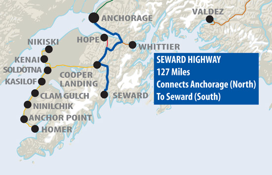
Bearfoot Map Of Anchorage Area Gold Towns
Bearfoot Travel Magazine
Map Of Gold Towns Near Anchorage
Copyright, 2017, Northcountry Communications, Inc.
Map Of Anchorage to Willow, Alaska
Bearfoot Travel Magazine
Map Of Anchorage to Willow, Alaska
Copyright, 2017, Northcountry Communications, Inc.
All Rights Reserved
Wasilla & Palmer, then on the Parks Highway to Houston & Willow.
(This map is an older map that shows the Wasilla-Palmer intersection as a "stoplight". It currently is a maze of incoming roads. However, the divergence at that point is still accurate.The Glenn Highway goes to the east, and the Parks to the west at that point.)
Map of Chitina and McCarthy Road
Map of Tok, Delta and Gakona Junction, Alaska
Bearfoot Travel Magazine
Map Of Tok, Alaska
Copyright, 2017, Northcountry Communications, Inc.
All Rights Reserved
Map of Wasilla, Alaska
Map of Whittier, Alaska
Map of Wasilla, Alaska
Map of Valdez, Alaska
Map of Turnagain Arm, Alaska
Bearfoot Travel Magazine
Map Of Turnagain Arm, Alaska
Copyright, 2017, Northcountry Communications, Inc.
All Rights Reserved

Map of the communities of Turnagain Arm near the Chugach Mountains in Alaska on the Seward Highway: Potter Marsh, McHugh Creek, Indian, Bird Creek, Girdwood, Whittier and Hope.

Map of Trapper Creek, Alaska
Map of Gakona Junction, Alaska
Map of Tok, Alaska
Map of Talkeetna, Alaska
Map of Sterling, Alaska
Map of The Sterling Highway, Alaska
Map of Soldotna, Alaska
Map of Seward, Alaska
Map of The Seward Highway, Alaska
Map of Richardson Highway, Alaska
Map of the Parks Highway, Alaska
Map of Palmer, Alaska
Map of North Pole, Alaska
Map of Ninilchik, Alaska
Bearfoot Travel Magazine
Map Of Ninilchik, Alaska
Copyright, 2017, Northcountry Communications, Inc.
All Rights Reserved
Map of Nenana, Alaska
Map of Mentasta & Nabesna, Alaska
Bearfoot Travel Magazine
Map Of Mentasta & Nabesna, Alaska
Copyright, 2017, Northcountry Communications, Inc.
All Rights Reserved
Map of Moose Pass, Alaska
Map of McCarthy Road, Alaska
Bearfoot Travel Magazine
Map Of McCarthy Road, Alaska
Copyright, 2017, Northcountry Communications, Inc.
All Rights Reserved
Map of Kenny Lake, Alaska
Bearfoot Travel Magazine
Map Of Kenny Lake, Alaska
Copyright, 2017, Northcountry Communications, Inc.
All Rights Reserved
Map of Kenny Lake, Alaska, showing the Richardson Highway, Copper River, Edgerton Highway, and Old Edgerton Highway. Also, Wrangell-St. Elias National Park.
Map of Kennicott, Alaska
Map of City Of Kenai, Alaska
Map of Kasilof, Alaska
Map of Houston, Alaska
Map Of Hope, Alaska
Map of Homer, Alaska
Map of Healy, Alaska
Map of Hatcher Pass, Alaska
Map of Gulkana & Gakona, Alaska
Map of Glennallen, Alaska
Map of the Glenn Highway, Alaska
Bearfoot Travel Magazine
Map Of The Glenn Highway, Alaska
Copyright, 2017, Northcountry Communications, Inc.
All Rights Reserved

Map of the Glenn Highway from Palmer to Glennallen, including Sutton, King Mountain, Matanuska Glacier, Sheep Mountain, Eureka, Nelchina, Mendeltan, Lake Louise, and Tolsona.

Map of Girdwood, Alaska
Map of Fox, Alaska
Map of Fairbanks, Alaska
Map of Ester, Alaska
Map of Edgerton Highway, Alaska
Map of Eagle, Alaska
Map of Denali State Park, Alaska
Bearfoot Travel Magazine
Map Of Denali State Park, Alaska
Copyright, 2017, Northcountry Communications, Inc.
All Rights Reserved
Map of Denali Park in Alaska
Map of Denali Highway in Alaska
Map Of Delta Junction, Alaska
Bearfoot Travel Magazine
Map Of Delta Junction, Alaska
Copyright, 2017, Northcountry Communications, Inc.
Subscribe to:
Comments (Atom)


